
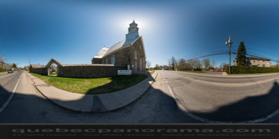
St. Mathias-sur-Richelieu est located on the right bank of the Richelieu River, 25 miles (40 km) from Montreal.
After Sorel and St. Ours, St. Mathias is the most ancient parish of the St. Hyacinthe bishopric. On February 24th, 1739 the population of East Chambly is authorized by Rev Louis Normand, chaplain of the bishop of Quebec in Montreal, to build a chapel and to set up a mission in the Pointe-Olivier area upon a pice of land given by lord Hertel of Rouville. This wooden chapel, blessed on November 24th, 1739, is dedicated to the Immaculate-Conception of the Blessed Virgin. By 1880, it was still possible to see, on the riverside, a little farther up than the Richelieu Co. quay, an underground wall which was the foundations of the portal of this first chapel.
Detached from St. Joseph parish ind Chambly, this new mission is served by the Recollets fathers from the mother-parish until 1769. Father Michel Levasseur, born around 1699, is ordained as a Recollet priest in Quebec on December 18th, 1723. Appointed as parish priest in Chambly in 1724 and chaplain for the King in the fort of Chambly, he is rightfully considered as the founder of the parish. It holds this function until September 4th, 1746. From 1769 till 1777, the mission is served by Rev Médard Pétrimoulx while the first resident priest, Rev Pierre Picard, a newly ordained priest, arrives. Meanwhile, on July 20th, 1772, the mission is dedicated to St. Olivier, in honour of Jean-Olivier Briand, first Catholic bishop of Quebec under the British regime, from 1766 till 1784.
280, chemin des Patriotes, Saint-Mathias-sur-Richelieu
Qc, CA
J3L 6A3

How to get there: Google Maps
Categories: Attractions, Religious buildings and sites
Card created: 05/2013
GPS coordinates: 45°28'26.81"N, 73°16'7.15"W
Download for your GPS: (.gpx)